Historic Urban Landscapes Ballarat
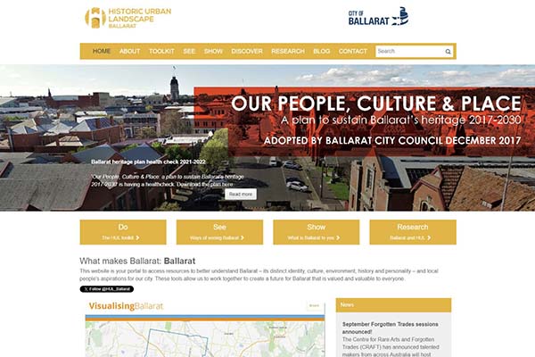
CeRDI and the City of Ballarat have collaborated on the Historic Urban Landscape (HUL) Ballarat web portal. The portal is one of the strategies developed for Ballarat, as a member of the United Nations Educational, Scientific and Cultural Organisation (UNESCO) Historic Urban Landscape Global project, to ensure the city continues to retain its character, landscape, and cultural significance as it grows.
The Historic Urban Landscape (HUL) and Visualising Ballarat project received the 2015 Victorian Spatial Excellence Award for People and Community.
 |
Background
In September 2013, the City of Ballarat became the first local authority in the world to become a signatory to implement UNESCO recommendations on the Historic Urban Landscape approach.
In partnership with the World Heritage Institute of Training and Research for the Asia and the Pacific Region (WHITR-AP), the City of Ballarat is implementing a innovative approach to urban planning. This process carries with it a commitment to ensure that Ballarat continues to retain, as an integral part of growth and development, the character of the landscape and the elements of cultural significance that make it unique.
Linked closely to the City of Ballarat strategic planning initiatives, HUL aims for the development of a synergy between the planning and development processes of the city and the complex and interrelated elements that make up a community within its lived environment.
In 2015 the Ballarat City Council adopted Today, Tomorrow, Together: The Ballarat Strategy ![]() , committing to implement UNESCO's Historic Urban Landscape approach as the guiding framework for managing change in this the historic City of Ballarat to 2030.
, committing to implement UNESCO's Historic Urban Landscape approach as the guiding framework for managing change in this the historic City of Ballarat to 2030.
The commitment to HUL represents a recognition that preservation of the physical environment constitutes only one element of planning sustainability; other factors to be considered in urban planning and design include community values, cultural factors, environment, built environment, socio-economic and local context, and the links that these elements have to the past and to the present.
With the use of innovative spatial mapping and knowledge management tools, the HUL interactive web portal has been designed to engage the community and enable users to easily access authoritative and credible information.
Identified as one component of the HUL suite of civic engagement strategies, the HUL web portal seeks to support community members, practitioners, researchers, and other key stakeholders to come together in an interactive way to contribute to planning for Ballarat.
The HUL portal demonstrates the role of information technology as a mechanism for inclusion, enhanced civic participation and knowledge building.
An associated project, Visualising Ballarat, offers state of the art knowledge management and urban planning tools to assist in assessing and monitoring change.
Outcomes
HUL Ballarat is helping to create an awareness of the urban landscape and its cultural significance and is expected to empower community members and local organisations to contribute to Ballarat’s future development.
The web portal allows an individual to ‘See,’ ‘Show,’ ‘Talk’ and ‘Research’ a range of ideas and thoughts.
Through the ‘See’ portal page, end users are able to see historic before and after images of Ballarat, access photo maps, view timelines, and an image gallery.
The ‘Show’ and ‘Talk’ pages provide opportunity for contribution through feedback and pictures. The fourth page ‘Research’ provides a range of resources for academic, industry and community researchers to learn more about the Historic Urban Landscape and about Ballarat.
Both HUL Ballarat and Visualising Ballarat have been designed to help stakeholders, community members, practitioners, and researchers to come together and identify community values, landscape values and acceptable levels of change.
Initial impact research was conducted by CeRDI’s Dr Angela Murphy and colleagues. This first wave of research sought to capture substantial base-line data to support the assessment of longer-term impacts of HUL Ballarat and Visualising Ballarat.
The research, which included input from a diverse range of participants, identified that the portals are beginning to be adopted as a platform for collaboration in the process of urban planning and development.
Key findings from the first wave of impact research included the following:
- The most accessed parts of the HUL web portal were those that contained imagery and mapping capacity (e.g., Visualising Ballarat and the Before and After photos); the visual elements of the web portal engaged end users and signalled a potential to build insights and new discoveries that could be tailored to individual interests and needs;
- While there is enthusiasm for the HUL web portal and the potential that it provides for use in consultation, planning and research, it is not yet a technological innovation that is accessed on a repeat basis by the majority of participants; there is a need for additional content to be added to the site.
- The HUL web portal has significant potential as a unique and important tool for community engagement, and for building connection and collaboration;
- The HUL web portal provides a unique resource to engage groups that have traditionally been excluded from the process of knowledge building and planning;
Overt measures of positive impact were found in increasing levels of usage, assessments of the quality of the portal content and the overall view that HUL Ballarat and Visualising Ballarat have the potential to facilitate community engagement and to build community connection and collaboration.
The majority of those involved in the interview component of this research felt that the portals were a means to establish partnerships and alliances throughout the community. Recommendations were provided to support future development of HUL Ballarat and Visualising Ballarat.
Research to examine the impacts on practice across and within community, planning, business, and research environments is continuing.
The Historic Urban Landscape (HUL) and Visualising Ballarat project received the 2015 Victorian Spatial Excellence Award for People and Community. The Award for People and Community recognises initiatives that make a difference to national, regional, or local issues and affect communities via ‘grass roots’ initiatives, and/or educational programs, services or tools that permit the widespread adoption, use, understanding and access to spatially enabled products or services.
-
RESEARCH OUTPUT
Murphy, A., Dahlhaus, P.G., and Thompson, H. (2016). Historic Urban Landscapes and Visualising Ballarat: citizen participation for sustainable urban planning and design. Locate 16: Disruptive Technology for a Smarter Society. 12–14 April 2016, Melbourne.
Murphy, A., Ollerenshaw, A., Taylor, M., Tsilemanus, A., Corbett, J., Thompson, H., Dahlhaus, P.G. Historic Urban Landscape and Visualising Ballarat Impact Analysis. CeRDI Report 2015. Available at http://www.hulballarat.org.au/resources/IMPACT%20ANALYSIS_First%20wave%20HUL_Report_FINAL2.pdf

A paper outlining CeRDI’s vision for Visualising Ballarat is at https://www.cerdi.edu.au/cb_pages/files/visualising_ballarat_past_present_future.pdf
-
VIDEOS
-
NEWS
CeRDI researcher authoring blog for Historic Urban Landscapes Ballarat - 28 June 2019
CeRDI Research Officer Helen Hunter is contributing as an author of the local history blog for Historic Urban Landscape (HUL) Ballarat. Continue reading...
HUL Ballarat: Town Hall Audio Tour - 23 January 2019
CeRDI has been working with the City of Ballarat to develop and deploy new content for the Historic Urban Landscapes (HUL) Ballarat website. Continue reading...
Ballarat Town Hall Audio Tour - "If these walls could talk" - 22 November 2018
The Ballarat Town Hall has stood at its current Sturt Street site for more than 150 years, with thousands of people visiting the building annually. Continue reading...
SongWays Music Mapping: Portal launch - 6 September 2017
CeRDI together with the City of Ballarat have established a spatial mapping archive of Ballarat's vibrant musical heritage. Continue reading...
Historic Urban Landscapes: First wave impact research - Autumn 2016
During 2015, impact research into HUL Ballarat was conducted by staff at CeRDI, led by Dr Angela Murphy. The first wave of research captured substantial baseline data from key stakeholders to support the assessment of longer-term impacts of HUL Ballarat. Continue reading...
Federation University and Corangamite CMA win Asia Pacific Spatial Excellence Award - 18 April 2016
CeRDI and the Corangamite Catchment Management Authority were recently awarded an Asia Pacific Spatial Excellence Award which was announced during the Locate16 conference in Melbourne.... Continue reading...
Promoting the Ballarat’s rich history with Historic Urban Landscapes Ballarat - Summer 2016
During 2015, CeRDI and the City of Ballarat collaborated on the Historic Urban Landscape (HUL) Ballarat web portal (www.hulballarat.org.au). Continue reading...
2015 Victorian Spatial Excellence Awards winners - 12 September 2015
CeRDI has been recognised and honoured at the Victorian Spatial Excellence Awards 2015 receiving both the Award for People and Community and the Award for Environment and Sustainability.... Continue reading...
Historic Urban Landscapes in Ballarat - 22 May 2015
In conjunction with the City of Ballarat, the Centre for eResearch and Digital Innovation (CeRDI) at Federation University has developed the Historic Urban Landscape (HUL) Ballarat web porta... Continue reading...
-
PARTNERS
City of Ballarat

The City of Ballarat is the lead organisation involved with this project as well as providing the funding for this project.
Public Record Office Victoria

The Public Record Office Victoria contributed content to this project.
Sovereign Hill

Sovereign Hill Ballarat assisted with project planning and development.

